


Hurricane Milton carved out a place for itself in history after undergoing explosive rapid intensification over the Gulf of Mexico and becoming the strongest Atlantic storm ever to form this late in the year.
But for many hurricane researchers and residents in storm-prone regions, Milton's initial pinhole eye and extreme wind speeds brought to mind another record-breaking storm: Katrina.
After peaking Monday as a powerful Category 5 storm with rarely seen sustained winds of 180 mph, Milton's eyewall collapsed, causing the storm to weaken slightly in intensity and grow in size. As of Wednesday, Milton weakened to a Cat 4 and was crossing into Florida's Gulf Coast as a high-end Cat 3 storm overnight.
Hurricane Katrina followed a similar pattern as it moved through the Gulf of Mexico toward Louisiana in 2005, peaking as a Category 5 storm with winds of 175 mph before growing in size, weakening and hitting land as a Cat 3.
It's not unusual for people to dredge up Katrina comparisons when faced with a major hurricane, and according to LSU professor and hurricane researcher Jill Trepanier, there are obvious similarities between Katrina and Milton.
“But Cat 5 systems are rare in the bulk of the historical data, and many times, those with this high-level intensity have similar features," Trepanier said. "That's what gets them to that place.”

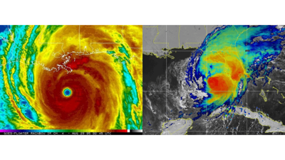
A satellite image of Hurricane Milton on Wednesday, October 9, 2024.
Such powerful storms often start as compact, symmetrical storms around pinhole eyes, Trepanier said, including Milton, Katrina and Hurricane Maria, which pounded Puerto Rico as a Category 4 storm in 2017.
Like Milton and Katrina, Maria rapidly intensified to Cat 5 strength before undergoing an eyewall replacement cycle that caused some weakening but growth in size before landfall.
But all hurricanes are unique in their own right, Trepanier said, and she said it's not always helpful to conflate two storms.
"This particular storm will be devastating without any comparison to Katrina."
What is an eyewall replacement cycle?
Milton had completed an eyewall replacement cycle overnight Monday, causing its sustained wind speeds to slow by around 30 mph by early Tuesday morning, according to data collected by the National Hurricane Center in Miami.
Eyewall replacement cycles are common in strong hurricanes and often cause growth in the storm's wind field size and fluctuations in its peak wind speeds, the NHC said.
Trepanier likened a hurricane's rotation to that of a figure skater: In the same way that smaller, compact storms with small eyes produce more intense wind speeds, a figure skater spins faster as she pulls her arms into her body.
But the faster a storm spins, the narrower its eyewall becomes, eventually forcing it to collapse. Since a storm's most powerful winds are located within its eyewall, this usually causes a hurricane to weaken.
And like how a spinning figure skater slows as she extends her arms away from her body, Trepanier said, a weakening hurricane often spreads itself out and grows in size.
Once the eyewall collapses, Trepanier said a new eye typically forms. A powerful storm with enough real estate over water can regain much of the strength lost during its eyewall replacement cycle.
Milton lost some strength after its eyewall collapsed but regained Category 5 strength Tuesday afternoon.
While some forecasters initially predicted Milton might undergo multiple eyewall replacement cycles at sea, Trepanier said late Tuesday that she didn't see that happening before landfall.
Hurricane Katrina
Katrina's path toward Louisiana and Mississippi differed from Milton's toward Florida in several ways, according to Phil Klotzbach, a hurricane researcher at Colorado State University.
While Klotzbach said Milton's wind field did grow by about 20% following the collapse of its eyewall and is expected to continue expanding, Katrina grew dramatically when its eyewall collapsed, nearly doubling the storm's overall size. That allowed hurricane-force winds to reach nearly 100 miles from Katrina's center, according to a University of Alabama report published in 2008.
Klotzbach also said, like Hurricane Idalia in 2023, Katrina was in the middle of replacing its eyewall when it hit land.
Though the eyewall replacement cycle contributed to Katrina's weakening, its double eyewall structure caused the location and arrival times of the storm's impacts to differ significantly from pre-landfall forecasts, according to the University of Alabama report. It also caused some locations to experience the passage of two eyewalls.
Weaker winds, larger in size
Milton had weakened to a Category 4 storm by Wednesday morning andwas expected to continue losing strength while battling shear near Florida's west coast. But the storm had grown in size, meaning its effects were likely to be felt far from the storm's center.
“Unfortunately, with Milton growing in size, it’s going to be a very robust surge event," Klotzbach said. And Florida's Gulf Coast is very prone to storm surge, he said.

A car sits half-buried in sand as Bradenton Beach, Fla., which was in the process of cleaning up after Hurricane Helene, as Hurricane Milton approaches on Anna Maria Island, Tuesday, Oct. 8, 2024.
But Klotzbach said the storm currently headed for Florida is not likely to near Katrina's massive size.
"I don't want people to think Katrina is coming at them," Klotzbach said.